Misleading: This Beijing air pollution image is old and digitally manipulated

[点击查看本文中文版]
On March 10, Beijing was hit by a dust storm that severely polluted the capital city, with an air quality index hitting a “hazardous” level of 1,093.
On the same day, a Twitter user posted a photo showing Beijing’s iconic buildings shrouded with a thick sheet of orange.
The tweet has garnered nearly 1,000 engagements at the time of writing. The same image also spread to other platforms, including LinkedIn and Facebook.
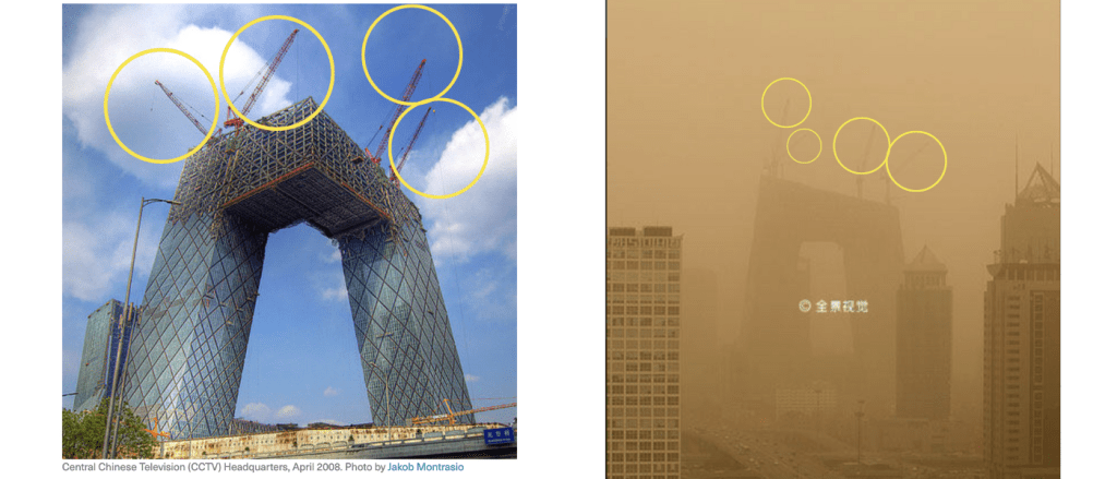
However, the photo in question is a manipulated version of a stock image shot in 2008, featuring the headquarters of state broadcaster CCTV — a landmark in Beijing’s Chaoyang district — that was under construction at the time.
Annie Lab found that the original photo is listed on the Chinese stock image website Quanjing.com. It is titled “Sight of Beijing’s First Sand and Dust Storms in 2008” and names Teng Ke as a photographer.
It is a sandy-toned photo featuring the CCTV Headquarters with several cranes on its rooftop.

We also discovered that this stock photo has been widely used over the past decade in many social media posts and internet articles (here and here) discussing the nation’s worsening sand and dust storm problems.
In most of these photos, the cranes were digitally removed from the CCTV building. The original sandy color was also enhanced into an orange hue, presumably to dramatize the image.

The manipulated orange-toned image and the 2008 stock photo share identical features, including traffic patterns and window shades in an office building.

We geolocated a structure that resembled a warehouse by the Tonghui Riverbank in the photo and found that it was removed in 2009 — further proof that the image was not taken in 2023.

Google Earth Pro’s historical image repository in June 2009 still shows the “blue-roofed warehouse,” but it is not visible two months later. A satellite image taken in 2010 shows the area is covered with trees.

We also examined the construction phases of the CCTV building.

According to a Google Earth Pro satellite image and a stock photo from Alamy, the two towers of the CCTV Headquarters appeared unconnected in November 2007.
A Flickr photo and another satellite image we found indicate that the two towers were connected into an L-shaped structure in April of 2008, with four cranes still visible on its rooftops at the time.
Satellite images show that by February 2009, only one crane remained on the building, and it was gone by June of that year.

The misleading tweet was posted on March 10 during the annual parliamentary sessions where lawmakers and political advisers across the nation gather in the capital city. It is one of China’s most important political events.
On March 22, Beijing and several nearby provinces experienced one of the worst air pollution days in recent years after the region was hit by a thick and dense sandstorm.
Northern Chinese metropolises often struggle with hazardous levels of PM 2.5, a tiny airborne particulate pollutant.
While air pollution has improved in recent years after authorities declared war against pollution in 2014, the region continues to battle with worsening dusty weather due to accelerating weather patterns intensified by climate change.

